
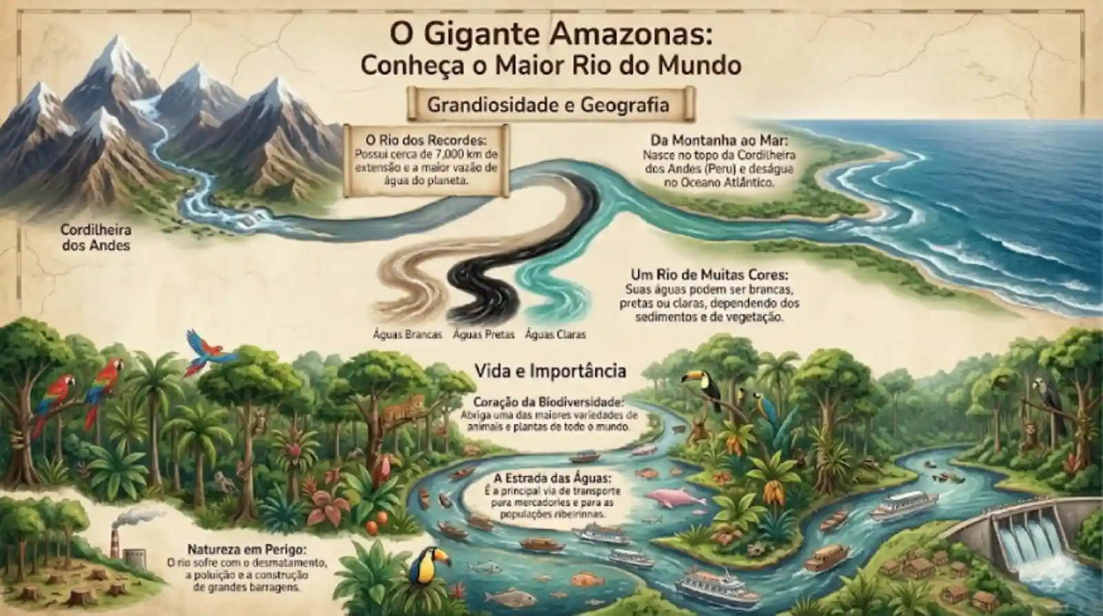
For decades, pinpointing the exact spot where the Amazon River begins was one of the great unfinished tasks of modern geography. The answer only arrived once two very different tools were combined: high precision GPS technology and exhausting overland expeditions, the kind that end with researchers walking the final stretch through thin air. Scientists and explorers eventually confirmed that the largest river on Earth, both by volume and by length, does not begin on the tropical floodplain at all. It begins above 5,000 metres, on Nevado Mismi, in the Peruvian Andes, where what will later become a 6,400 kilometre giant starts as a modest trickle of meltwater from glaciers thousands of years old.
From the Quebrada de Apacheta to the Apurimac
Recent expeditions, including one by a Brazilian who rode a motorcycle up the cordillera to document the headwaters, reinforce a point scientists have been making for years: the Amazon is, above all, a vertical hydrological system. The starting point, in the Quebrada de Apacheta, feeds the Apurímac River, which joins other tributaries to form the Ucayali and later the Solimões and the Amazon itself. That connection is not a cartographic footnote. The chemical composition of the water that bathes the rainforest depends directly on the mineral sediment carried down from the top, in the coldest and most remote corners of Peru.
Understanding the headwaters is also a matter of continental water security. According to data from the Geological Survey of Brazil (CPRM), the flood and drought cycle of the Brazilian Legal Amazon is a direct reflection of what happens in the Andean uplands. Protecting those remote areas is not merely a question of Peruvian sovereignty, it is a question of cross border ecological balance, because any change in Andean glacial melt reaches the level of the rivers that sustain biodiversity and riverside communities thousands of kilometres downstream.
The chemical secrets stored at altitude
Science describes these remote springs as keepers of geochemical secrets that work like the river DNA. The famous white or muddy waters of the Amazon owe both their colour and their fertility to the Andes. As they rush down steep slopes, they go through a natural leaching process and pick up essential nutrients such as calcium, magnesium and potassium. Those minerals are the reason the Amazonian floodplains, the várzeas, rank among the most productive soils on the planet, and the reason the so called Indian black earth and highly complex ancestral farming systems developed there long before any modern agricultural technology existed.
Beyond fertility, the headwaters serve as natural laboratories for climate change research. The retreat of Andean glaciers, documented by institutions such as the IPCC, alters the initial flow of the river. Researchers monitor these remote threads of water to anticipate the future of the biome. If the Andean tap changes its rhythm, the entire life cycle of the basin may feel it, from the growth of the peach palm, Bactris gasipaes, to the breeding of the harpy eagle, Harpia harpyja, species that depend on a predictable pulse of rising and falling water to complete their cycles.
Why remote headwaters carry so much environmental weight
Protecting the remote springs works as the definitive thermometer of the health of the Amazon basin. These are regions extremely sensitive to mining and to high altitude grazing, activities that can contaminate or destabilise the ground exactly where the water begins its journey. Conserving those snow covered peaks is what guarantees that the Amazon keeps receiving pure, mineral rich water. The Brazilian expedition to Nevado Mismi underlines how important it is to document such places, so that civil society and governments grasp something counterintuitive: the Amazon does not begin in the rainforest, it begins in the ice.
International cooperation initiatives, such as those promoted by the Amazon Cooperation Treaty Organization (ACTO, known in the region as OTCA), aim to create protection protocols for these critical zones. Valuing the whole path of the water, from the frozen thread in the Andes to the monumental mouth in the Brazilian states of Pará and Amapá, is essential for any sustainability model that treats the river as a single living organism. The science on this point is blunt: saving the Amazon River means protecting its most distant and silent origins.
Expeditions and the future of scientific fieldwork
Adapted vehicles, from motorcycles to high altitude drones, have opened up exploration of areas once out of reach for large teams. A single researcher can now document the condition of the headwaters in real time and feed decisive data into hydrological forecasting models. That modern field science, combined with the knowledge accumulated by institutions such as the National Institute for Amazonian Research (INPA), allows monitoring of the water cycle at a level of detail the region has never had before.
The future of scientific exploration in the Amazon lies in pairing technology with geographic respect. Every new expedition into the heart of the Andes brings back another piece of the puzzle that explains why this river matters so much to the global climate. The remote springs are, in the end, the guarantee that the pulse of the planet is still beating strongly, and documenting them is itself an act of preservation of the greatest natural heritage humanity holds.
A vertical river, from ice to floodplain
What the expeditions to Mismi make visible is a river that behaves less like a line on a map and more like a staircase. Water leaves the glacier, cuts through rock, gathers minerals, drops thousands of metres, and only then spreads across the lowland forest that most of the world pictures when it hears the word Amazon. Each step of that descent changes what the water carries, and therefore what the forest downstream receives. Treating the mountain and the jungle as separate subjects, studied by separate specialists under separate national policies, misses the single mechanism that links them.
From meltwater thread to the Meeting of the Waters
Although the geographic source sits in Peru, one of the most famous spectacles of the Amazon system happens near Manaus, in Brazil: the Meeting of the Waters. There the Solimões River, muddy and loaded with Andean minerals, runs into the Rio Negro, dark and rich in organic acids from the forest. Because of differences in density, temperature and speed, the two flows refuse to mix for several kilometres, travelling side by side with a visible line between them. The phenomenon is the clearest possible proof of a hydrological diversity that starts in the remote headwaters and keeps transforming as it crosses the continent.
The story of the Amazon origins is a reminder that the greatest forces in nature usually begin with the humblest of movements. A silent drip at five thousand metres sustains the largest tropical forest on Earth and regulates the climate of entire continents. Understanding how fragile and how important those remote springs are is an invitation to think about how every ecosystem is connected: what happens at the top of the mountain echoes deep inside the jungle. Protecting the Amazon means, above everything else, honouring its long vertical journey through the veins of South America.
Reporting: Anne Silva / Amazonia Mag. Source: Geological Survey of Brazil (CPRM), IPCC, Amazon Cooperation Treaty Organization (OTCA) and the National Institute for Amazonian Research (INPA).

Editor · Amazonia Mag
Anne Silva is the editor of Amazonia Mag, the English-language edition of Revista Amazônia. She curates, translates and adapts the outlet's science and environment coverage for an international audience, reporting on Amazon wildlife, flora, rivers, climate and research. Every story she edits is grounded in peer-reviewed studies, official data and on-the-ground reporting from the Revista Amazônia newsroom in Belém, Pará, Brazil. More by Anne Silva →